Three-Layer Architecture
PlumeSentinel AI is structured in three layers that work together at operational tempo:
- Physical Forecast Layer — federal smoke and fire forecast products plus complementary research models.
- Agentic AI Platform — grounded, agentic workflows that fuse observations and forecasts into a current incident state.
- Decision Support and Communication — wildfire smoke briefings, ranked actions, public messaging.
Satellite Imagery
Two complementary satellite systems anchor the observational backbone — polar-orbiting VIIRS (Visible Infrared Imaging Radiometer Suite) for high-resolution spatial detail, and geostationary GOES ABI (Geostationary Operational Environmental Satellite — Advanced Baseline Imager) for continuous temporal tracking.
VIIRS: Wildfire Smoke Plume Detection
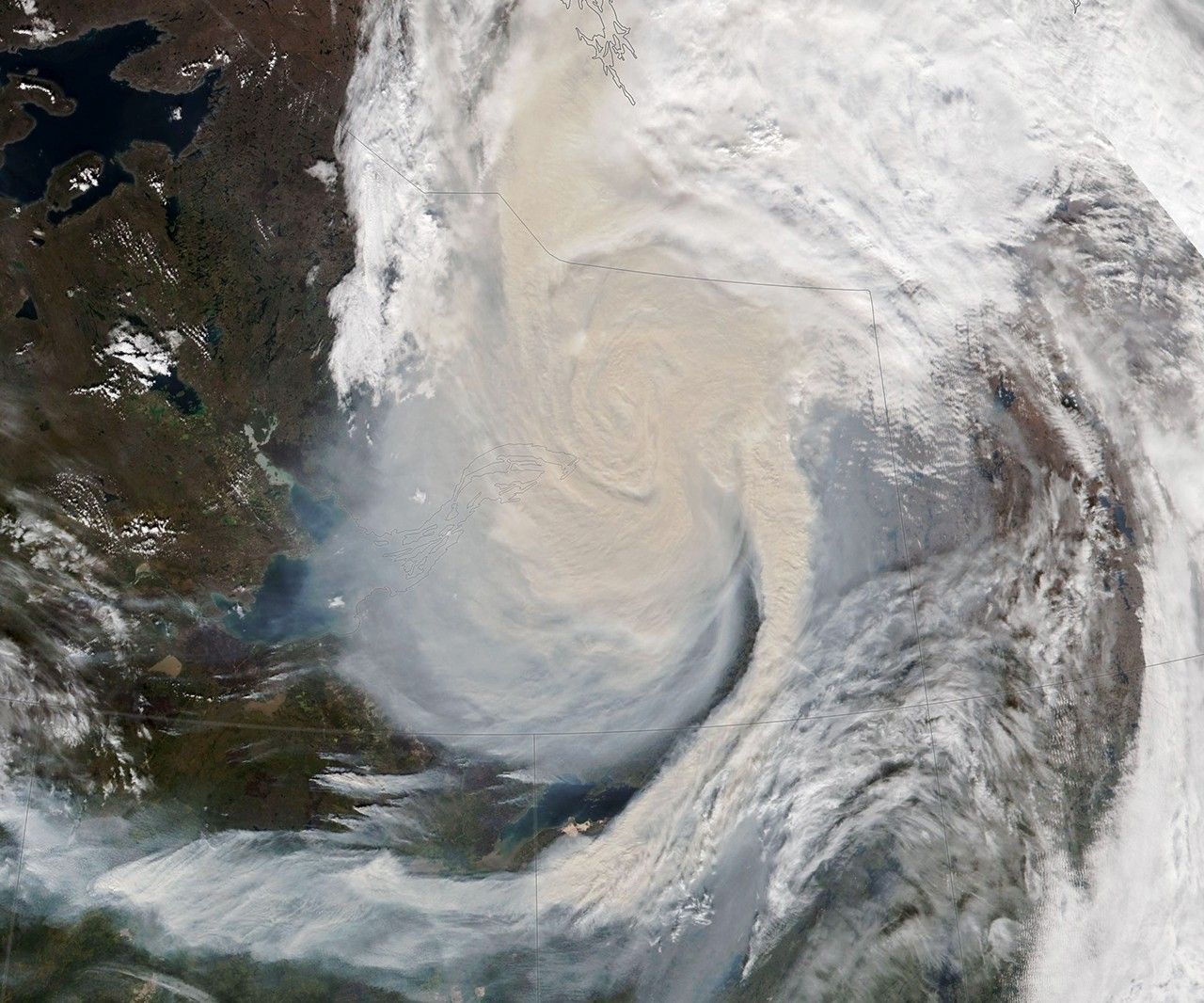
A Smoky Cloud Swirl over Northwest Territories
VIIRS true-color image from NOAA-20 (the second satellite of the Joint Polar Satellite System), September 16, 2023. Smoke from boreal wildfires forms a dramatic spiral spanning hundreds of kilometers, driven by upper-level wind shear. VIIRS captures both the spatial extent of the plume and the thermal anomalies that generate it.
Credit: NASA Earth Observatory / Lauren Dauphin, using VIIRS data from NASA EOSDIS (Earth Observing System Data and Information System) LANCE (Land, Atmosphere Near real-time Capability for EOS), GIBS (Global Imagery Browse Services)/Worldview, and JPSS (Joint Polar Satellite System). science.nasa.gov →
GOES ABI: Continental-Scale Smoke Tracking
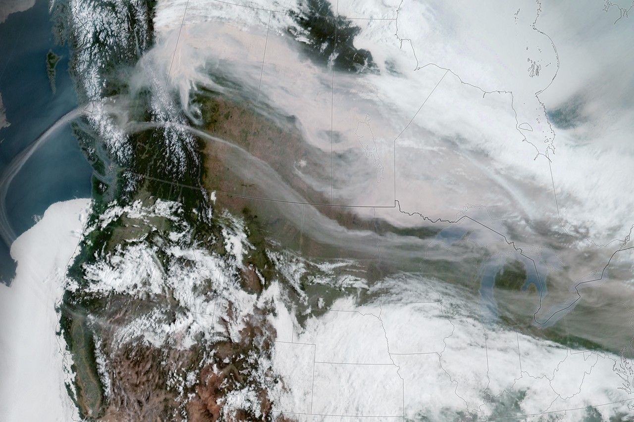
Smoke Fills North American Skies
GOES-18 geostationary image, May 15, 2023. Canadian wildfire smoke sweeps across multiple U.S. states. Unlike polar-orbiting VIIRS (~2 passes/day), GOES captures imagery every 5–15 minutes — real-time plume tracking at the cadence PlumeSentinel AI needs.
Credit: NASA Earth Observatory / Lauren Dauphin, using GOES-18 imagery courtesy of NOAA (National Oceanic and Atmospheric Administration) and NESDIS (National Environmental Satellite, Data, and Information Service). science.nasa.gov →
Operational Forecasts
National Weather Service smoke and fire forecast products provide the physical backbone:
- Operational regional smoke forecasts at high spatial resolution
- National air-quality forecasting at synoptic scales
- Next-generation experimental smoke and dust products
- Upstream fire detection and emissions inputs
Independent Validation
Forecasts are continuously compared against observations:
- Polar-orbiting and geostationary satellite aerosol products
- Surface PM2.5 reference monitoring
- Operational hazard mapping analyses
- Confidence diagnostics for every forecast product in use
Agentic AI Platform
The core operations layer uses grounded, agentic workflows to:
- Integrate live observations and forecast outputs into a current incident state
- Track provenance, confidence, and uncertainty across products
- Run scenario analyses and rank response options
- Coordinate human review and escalation
Decision and Communication
The decision-support layer converts incident intelligence into public-sector action:
- Operator-facing wildfire smoke briefings
- Ranked action options for agencies
- Health-protective recommendations
- Audience-specific public messaging drafts
- Auditable records for after-action learning
The 15-Minute Promise
Reduce the path from plume detection to decision-ready briefing from hours of manual synthesis to under 15 minutes.